Strangling the downstream to protect the upstream... a reading of the timeline of Turkish water violations
The Euphrates, once a lifeline, has become a noose threatening downstream countries due to Turkish water policies and engineering practices that disregard international laws and customs.
Silva Ibrahim
News Center – The Euphrates, the historic artery of Mesopotamia, is no longer a river governed by nature but a pipe whose valves are controlled by Turkish water politics. A harsh equation paid for by Syrians and Iraqis: if rain is scarce or the upstream economy falters, water is cut off and the river dries up for the downstream countries; if Turkish dams overflow and Ankara fears for the safety of its facilities, water is released without warning, turning the flow into a flood that inundates lands and farms on its banks, as witnessed in the Syrian cities of Deir ez‑Zor and Raqqa last May.
Since the dawn of history, the name Mesopotamia has been linked to the flow of the two rivers, where nature was the sole ruler of water levels and seasons of abundance. Today, however, the Euphrates has entered an era of geographical captivity, and its international course has become an arena of silent and violent struggle between upstream and downstream countries. The current Euphrates crisis is not merely the result of climate change; it is the product of water engineering and politics imposed by truncated agreements and unilateral desires. This dossier sheds light on the river's geography, the disputed shares of the countries, and international legal violations, reviewing the dangerous historical shift of the river from its most critical drought periods in recent years to the catastrophic flood flows recently witnessed in the region.
Where does the Euphrates originate?
The Euphrates River originates in the mountainous highlands of eastern Turkey (Taurus Mountains). It is formed mainly by the confluence of two tributaries: the Murat River, which rises in the area between Lake Van and Mount Ararat, and the Kara Su, which rises in northeastern Turkey near Erzurum. These two tributaries meet near the Turkish town of Keban to form the main course of the Euphrates, which flows southwards, enters Syrian territory near Jarabulus, then crosses into Iraq near Al‑Qa'im, finally merging with the Tigris River in southern Iraq to form the Shatt al‑Arab, which empties into the Arabian Gulf.
The total length of the Euphrates is approximately 2,800 kilometers, and in some measurements including meanders, it may reach 2,940 km. This length is distributed among the three countries: Turkey, where the river originates, accounts for about 1,176 km (42% of the river's length); Syria, where the river flows for about 610 km (22%); and Iraq, where the river flows for about 1,160 km (36%).
Each country's share of Euphrates water
In 1987, Turkey pledged to release a dam with an average flow of no less than 500 cubic meters per second at the Turkish‑Syrian border, equivalent to a total volume of approximately 15.75 billion cubic meters per year.
In 1989, Syria and Iraq agreed to divide the water passing through the Turkish border into Syria (the 500 cubic meters per second) as follows: Iraq receives 58% of the water coming from Turkey, i.e., about 9.13 billion cubic meters annually as a minimum, while Syria receives 42%, i.e., about 6.62 billion cubic meters annually.
Roots of the dispute between upstream and downstream countries
Turkey does not officially recognize the terms "share" or "water division," as it considers that it has the right to use the water to fill its dams (such as the Atatürk Dam) for its agricultural projects. This causes continuous disputes between the three countries over actual shares, especially during drought seasons.
International law obliges states sharing a river (upstream and downstream) to abide by a number of principles to ensure access to drinking water for all. Every state has the right to an equitable and reasonable share of the river's water to meet its basic needs such as drinking.
It is forbidden for any state to build projects (such as dams) or take actions that might pollute the river's water or reduce its quantity, thereby infringing on other states' right to drinking water.
States are obliged to notify and consult with other states before making any change to the river's course or building new facilities, to avoid any water crisis.
Timeline of major Turkish water violations
The first signs of the crisis appeared when Turkey began filling the Keban Dam reservoir (the first large dam on the Euphrates). Concurrently with Syria's filling of the Euphrates Dam, this caused a sharp and sudden drop in water flow toward Iraq, nearly sparking a military war between Syria and Iraq had it not been for Soviet and Saudi international intervention and mediation to avert the crisis, while Turkey watched and continued its hegemonic plans.
In the late 1970s, Turkey consolidated its water projects into a giant project called the Southeastern Anatolia Project (GAP), which includes the construction of 22 dams and 19 hydroelectric power plants on the Tigris and Euphrates rivers. Legally, Turkey began implementing this massive project without obtaining "prior approval" from Syria and Iraq, and without studying the environmental and water impact on downstream countries, which constitutes a flagrant violation of international water law customs.
In 1990, Turkey completely cut off the Euphrates water for a full month (from January 13 to February 12, 1990) to divert the river's course and begin filling the Atatürk Dam reservoir (the giant of the GAP project). This act was carried out unilaterally by Turkey and led to the drying of vast agricultural areas in Syria and Iraq. Both countries considered it a "flagrant violation" of the 1987 treaty that obliged Turkey to pump 500 cubic meters per second.
Violations were not limited to the main course. In the 1990s, Turkey built dams and barriers on the springs feeding the Khabur River (the largest tributary of the Euphrates within Syria). By 2001, the Khabur River had completely dried up for the first time in modern history inside Syrian territory, causing the loss of a vital agricultural basin covering about 20,000 square kilometers and depriving hundreds of villages of drinking water.
International legal bodies, Syria, and Iraq classified these behaviors as "illegal violations" based on Turkey's breach of the principles of the 1966 Helsinki Rules and the 1997 UN Convention on the Law of the Non‑Navigational Uses of International Watercourses. Although Turkey refused to sign the 1997 Convention and was one of only three countries in the world to vote against it, the principles of the Convention, such as "not causing significant harm to other states" and "prior notification before constructing water facilities," are considered customary rules binding internationally even on non‑signatories.
The 1982 Nairobi Environmental Declaration prohibits states from managing their natural resources in a way that causes environmental degradation to neighboring states (as evidenced by the salinization of southern Iraq and the drying of the marshes).
The drought wave that hit Syria and Iraq
The Euphrates recorded its lowest flow rate and a historic drought level in Syria during the period between 2021 and 2022, considered the harshest in the river's modern history within Syrian territory. Water inflows dropped unprecedentedly due to a combination of political and climatic factors. The water flowing from the Turkish side into Syria fell from the internationally agreed minimum (in the 1987 agreement) of 500 cubic meters per second to only about 200 cubic meters per second at the peak of the drought. Water levels in the lakes receded; the water level in Lake Assad behind the Euphrates Dam and Lake Tishrin Dam dropped by up to 5 meters vertically, bringing the lakes close to the "dead level" (the level at which turbines and pumps stop working).
The main reasons behind the historic decline in water quantity were the large amounts of water retained behind the massive dam network upstream (within Turkey's GAP project).
From drought to floods
Turkey's excessive water storage in previous years made the water system fragile. When heavy rains came, this storage turned into a danger that backfired on everyone. Over the past drought years, Turkey had been holding back the largest share of incoming water to secure its reserves in the Atatürk Dam, Keban Dam, and Ilisu Dam (on the Tigris), without regard for the needs of Syria and Iraq. By the beginning of the winter and summer of 2026, Turkish lakes were already filled to levels very close to their maximum capacity. When historic rains fell and snow melted all at once in the Taurus Mountains, Turkish dams could no longer absorb a single additional drop of water.
Turkey protected its dams at the expense of downstream countries
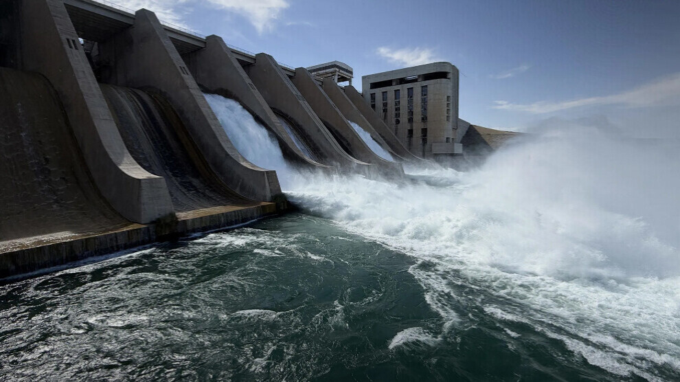
According to water engineering, if water exceeds the dam's maximum level, it poses a hydraulic risk that could lead to cracking or collapse of the dam – an existential disaster for Turkey. To save its dams, Turkey once again acted with geographical selfishness: it opened the spillway gates completely and pumped water at a terrifying rate exceeding 1,000 cubic meters per second toward Syria and Iraq to dispose of the excess water burden. If Turkey had followed a sustainable management policy with fair continuous pumping in previous years, its dams would have been partially empty and ready to absorb floodwater and release it gradually without inundating Syrian and Iraqi villages.
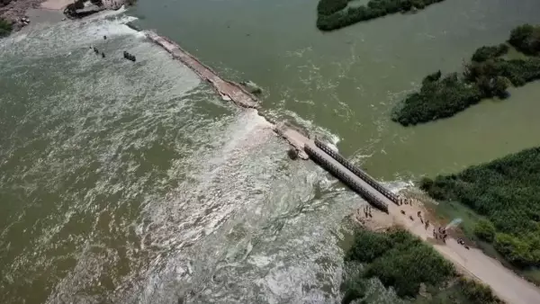
This wave caused the river to flood and its levels to rise continuously in Raqqa and Deir ez‑Zor, flooding vast areas of agricultural land along the river. Earthen and temporary bridges, such as the Al‑Mayadin Bridge, were affected, and local ferries stopped operating.
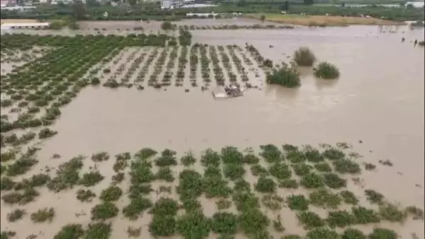
This wave also caused a state of panic and significant material losses for residents of areas along the river. According to the preliminary toll announced by the Syrian Observatory for Human Rights yesterday, Sunday, May 31, the number of affected families in the western and eastern countryside of Deir ez‑Zor reached 3,769 families, while thousands of hectares of agricultural land were damaged, and the number of fully or partially destroyed homes reached 1,075.